The Virgil Gilman Trail
The Virgil Gilman Trail is an 11.5 mile trail that runs northwest from Hill Avenue in Aurora, Illinois to Waubonsee College in Sugar Grove, Illinois. The northwest part of the trail ~ west of the Fox River ~ has some nice wooded areas with tall trees and a variety of distinctive bridges.
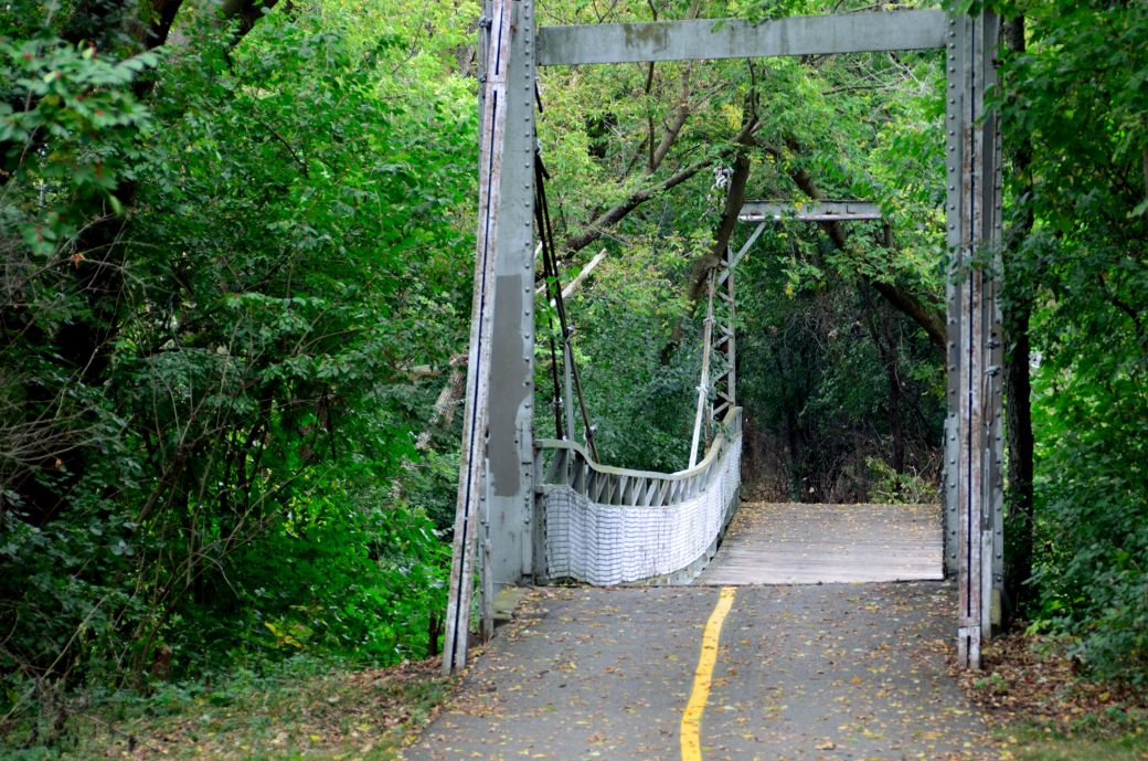 The Crooked Bridge in the woods on the Virgil Gilman Trail. |
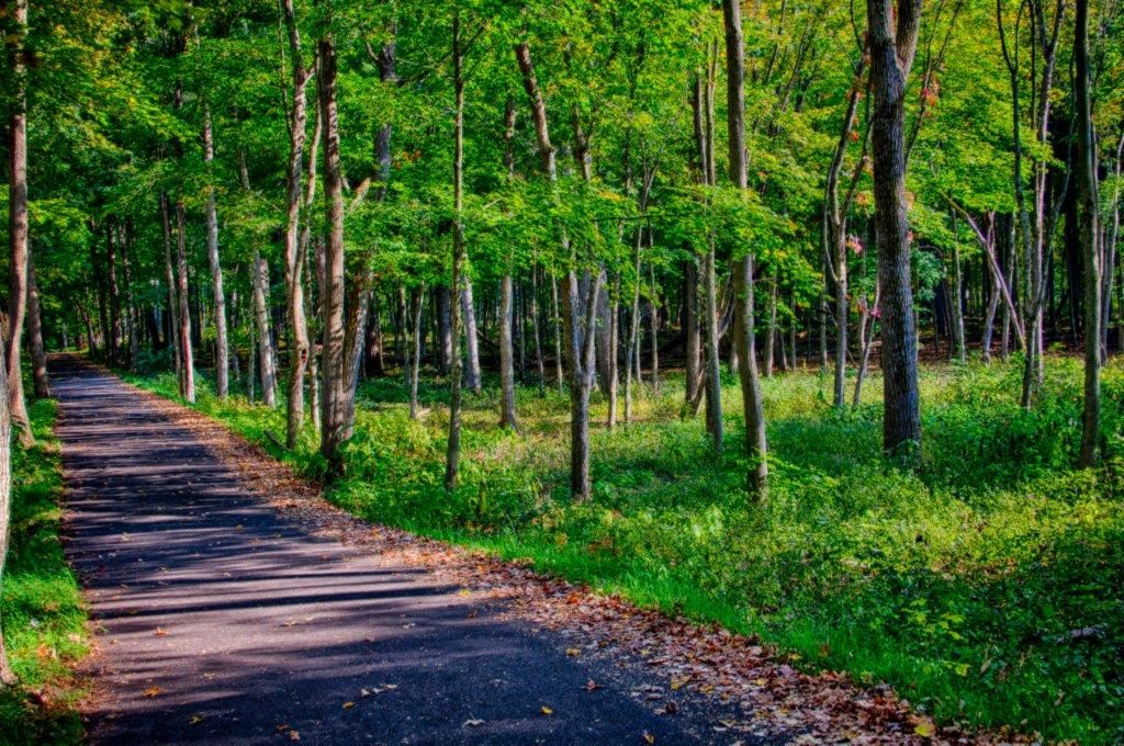 The woods near the north western end of the trail (HDR photo). * |
 The bridge over Galena Avenue. |
The Virgil Gilman Trail (VGT) is paved, mostly flat and passes through the town of Aurora, over the Fox River, through some tunnels and a small industrial area then through a number of wooded areas, parks and forest preserves as you head northwest.
For me, the nicest part of the trail is the northwestern end of the trail from about a mile or so west of the Fox River to the northwestern end of the trail at Waubonsee Community College in Sugar Grove. I loved the wooded areas and tall trees in this part of the trail along with the variety of different kinds of bridges (from very old to very new).
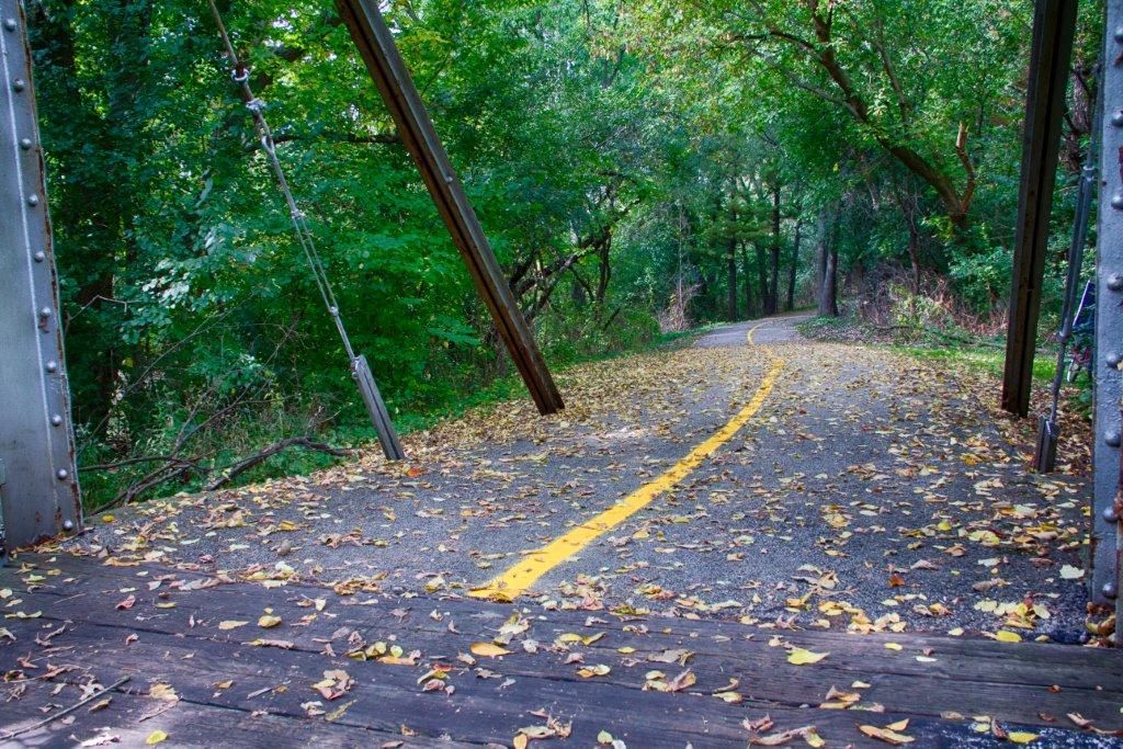 A view of the Virgil Gilman Trail from the Crooked Bridge. * |
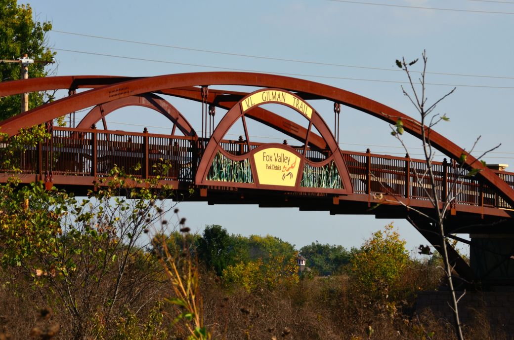
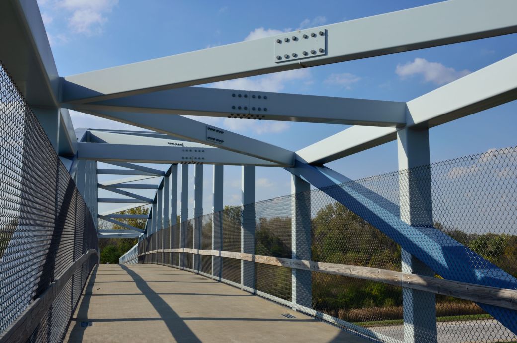 The Large Steel Bridge that takes you over Route 56. |
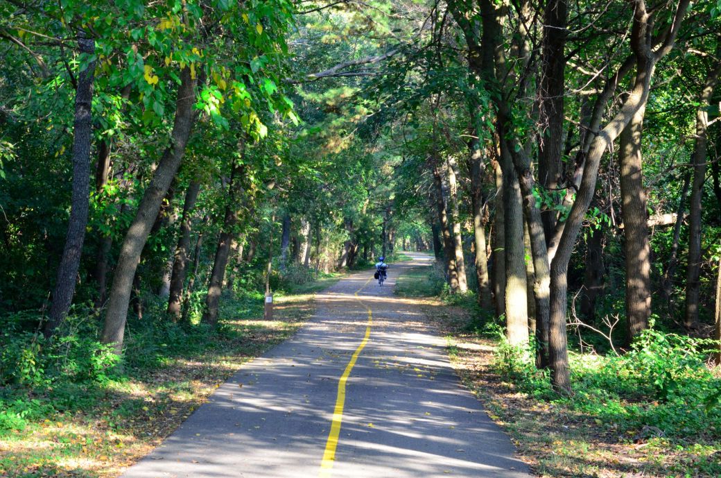 A recumbent rider under the tall trees on the Virgil Gilman Trail. |
Our Ride on the Virgil Gilman Trail
I have ridden past the Virgil Gilman Trail a few times as I rode the southern part of the Fox River Trail and was always curious what this trail was like. This year a friend and I planned our Virgil Gilman Trail ride in October hoping to get some photos with some nice fall color. Unfortunately, the trees had not started to show their color yet this year but on the other hand, the trail had some nice scenic areas and other interesting features which provided us with some nice photo ops.
We actually started our ride at the southern end of the Fox River Trail in Oswego and headed north to Aurora where the FRT intersects with the VGT. Once we got on the VGT we headed to the southeastern end of the trail ~ on Hill Avenue in Aurora ~ then turned around and rode the entire trail to Waubonsee Community College in Sugar Grove.
The far southeastern end of the trail was OK but going through Aurora at the Fox River and just west of the river was not very nice. Just west of the river we noticed a wine bottle on the trail and a bunch of broken bottles next to the trail. There was a fairly large group of homeless people sitting around drinking not far from the trail.
My friend asked one of the people that maintained the trail about this which is how we know that most of this group of people were homeless. It was OK to pass through on the trail but this is really not a very nice area. After that you go through some small industrial areas and the trail continues on some streets (Rathbone Ave and Terry Ave) before connecting back the the regular trail again.
Once you are a little over a mile west of the Fox River you really start to get to the best part of the trail. Most of the photos in the photo tour below are from this part of the trail. The trail ends at Waubonsee Community College in Sugar Grove, which is where we stopped for a break before turning around and heading back to Oswego.
Waubonsee College is a small college and has a lunch room, vending machines and a nice outdoor area with tables and chairs. Unfortunately we took our ride on a Friday and the cafeteria closes early on Fridays and we got there just after it closed.
We had some healthy snacks with us and also got some (unhealthy) food from the vending machines and had our lunch at the outdoor eating area. It was a great place for a lunch break! After our break we rode back on the northwestern part of the VGT back to the FRT in Aurora.
The Virgil Gilman Trail Map
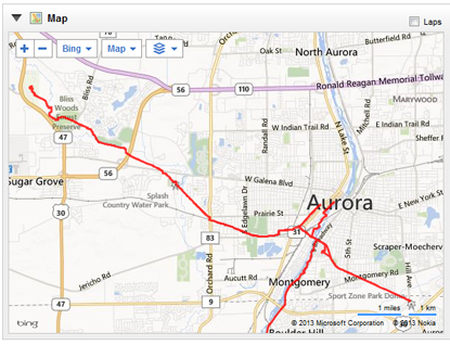
Below is the GPS Map of our ride on the southern end of the Fox River Trail and the entire Virgil Gilman Trail. The 2 north south sections of our route that go into Aurora on the west side of the Fox River is where I was exploring new ways to get through Aurora and connect to the Fox River Trail on the north end of Aurora. Neither of these routes were very good and I would not recommend them.
Fox River Trail Bike Lanes Through Aurora - Update 5/28/2016
If you are riding the Fox River Trail and want to continue north through Aurora, I have some great news! You can now go through Aurora on some very nice bike lanes. Now you can ride the entire FRT, from Algonquin to Oswego without the problem of getting through Aurora.
A well informed visitor to this site told me about the bike lanes through Aurora last fall (2015) when they were still under construction. This year I just got on to that part of the trail and checked them out myself. They are very nice and keep you seperated well from traffic. Just follow the bright green bike lanes through town.
Here's a link to a page that I just posted about the Bike Lanes through Aurora.
The Virgil Gilman Trail Interactive GPS Map
Below is a Map of my ride on the southern end of the Fox River Trail and the entire Virgil Gilman Trail from Aurora to Sugar Grove with a link to the GarminConnect site so you can review the route, map, connecting trails and surrounding area.
If you take the map link to the Garmin site, you can easily zoom-in, zoom-out, move around or switch to the satellite view as you wish.
The Virgil Gilman Trail Map
© Copyright Garmin and Microsoft.
(click on map to see full map/ride details)
| . |
Virgil Gilman Trail Trail Photo Tour
Here's the photo tour of the Virgil Gilman Trail starting in Oswego, Illinois (on the Fox River Trail) connecting to the Virgil Gilman Trail in Aurora then riding the entire trail from Hill Avenue to Waubonsee Community College in Sugar Grove, Illinois. This ride was in October, 2013.
Virgil Gilman Trail Home < you are here
Virgil Gilman Trail Photos 1 - Fox River Corridor and SE
Virgil Gilman Trail Photos 2 - Palmer Park and Crooked Bridge
Virgil Gilman Trail Photos 3 - Steel Bridge to Waubonsee College
Enjoy your ride...
Photos © Copyright Rob Chapman, about-bicycles.com. Photos with * Copyright Dale Kiffel.
- Bike Computers
- Bicycle GPS
- Bicycle Bags
- Bicycle Clothing
- Bicycle Lights
- Bicycle Locks
- Bike Parts
- Bikes
- Kids Bikes
- Exercise Bikes
- Bike Trainers
- Bicycle Car Racks
- Bicycle Hydration
- Bicycle Accessories
- Bike Blog
The VGT Photos1
The VGT Photos 2
The VGT Photos 3
- Algonquin Road Trail
- Busse Woods Trail
- Chain O'Lakes Trail
- Chicago Lakefront Trail
- Deer Grove Bike Path
- Des Plaines River Trail
- Evanston Lakefront
- Fox River Trail
- Great River Trail, Illinois
- Great Western Trail
- Green Bay Bike Trail
- Hennepin Canal Trail
- I&M Canal Bike Trail
- Illinois Prairie Path
- Illinois State Beach Bike Path
- Inverness Trail
- Jane Addams Trail
- Kankakee River Trail
- Long Prairie Trail
- Millennium Trail
- Moraine Hills Trails
- North Branch Trail
- North Shore Bike Path
- Old Plank Road Trail
- Palatine Trail
- Paul Douglas Trail
- Poplar Creek Trail
- Prairie Trail
- Prospect Heights Trail
- Randall Road Trail
- River Bend Trail
- Robert McClory Bike Path
- Silver Glen Trail
- Skokie Valley Trail
- Thorn Creek Trail
- Virgil Gilman Trail
- Wauponsee Glacial Trail
- 400 State Trail
- Ahnapee Bike Trail
- Badger State Trail
- BATS Crystal Lake Trail
- Cannonball Path
- Elroy Sparta Trail
- Great-River-Trail
- Kenosha Trail
- LaCrosse-River-Trail
- Military Ridge Trail
- Oak Leaf Trail
- Peninsula State Park Trail
- Red Cedar Trail
- Root River and Racine Trails
- Seven Waters Trail
- White River Trail