The Mammoth Cave Trail
The Mammoth Cave Trail is a very hilly crushed stone trail ~ about 8 miles long ~ that runs from the Mammoth Cave Park main visitor center south, and mostly close to the the Mammoth Cave Parkway entrance road, to the outskirts of Park City (just south of the park).
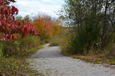
 Some nice October colors on the Mammoth Cave Trail.. |
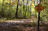
 One of the very steep grades on the Mammoth Cave Trail |
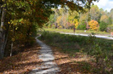
 A few parts of the MCT become a narrow single track sections.. |
The Mammoth Cave Trail (MCT) is a biking and hiking trail in the Mammoth Cave National Park in Kentucky. Just to be clear it is not any kind of trail through Mammoth Cave. The trail never veers too far from the Mammoth Cave entrance road and crosses the road in various places.
The trail is very wooded, curvy and hilly. There are a few steep grades (well marked) where it says that you are supposed to walk your bike. That was no problem for me because I was not able to ride UP the grades. I was, however able to ride DOWN but only with both brakes on and very slowly and carefully (not recommended for rookies).
My Ride on the Mammoth Cave Trail
I started my ride on the MCT at the main visitor entrance to Mammoth Cave National Park. It's not hard to find the trail where you part at the visitor entrance especially since it runs parallel and right next to the park entrance road just before you get to the main parking lot. Don't worry though, the trail goes off into the woods after that part.
They call the MCT a biking and hiking trail. Originally I thought that meant that it was for bikers and hikers but after I rode the trail I realized that, for me anyway, it was a biking and hiking trail at the same time! :-)
There are a couple of places where the trail forks off into to directions and it is not marked well which is the main trail (so check the maps). I was not sure where to go at one of the forks and asked another biker on the trail.
The other biker was friendly and very helpful. He said that he rode the trail about 3 times a week (so he know it well). He told me which way the main path was at the fork and when I mentioned how tricky the surface was on my road bike, he suggested letting a little air out of my tires for better traction.
I remembered doing that in another situation and thought it was a good idea. I think that helped but then I had another tire issue later which I think was unrelated. Anyway, I made it through the entire trail and thought deflating the tires on my road bike was a good idea for this trail.
Since my ride was from the end of October, the photos that I took on this ride are pretty close the peak fall color season.
The Mammoth Cave Trail Maps
I am including the Google Maps version of the trail ~ so you can get right to it without having to search and zoom in ~ in addition to my GPS map on the Garmin Connect SIte and a photo of a map that I took at the visitor center at the park.
Each map has different features that can be helpful so you can take your pick of which one you like the best.
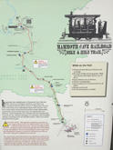
Here's the Mammoth Cave Trail map from the sign posted at the visitor center. Click on the map photo to see the larger version.
(Click here or on the map for the full size version).
Here is the GPS Map of Our Ride on the Mammoth Cave Trail through the GarminConnect site.
Here is the Google Maps version of the Mammoth Cave Trail. Note: At this time, this particular Google Map has a gap in the trail between the visitor center and Sloans Crossing Pond. The bike trails on Google Maps are usually very accurate so hopefully they will get this fixed soon.
| . |
Mammoth Cave Trail Photo Tour
Here's the photo tour of the Mammoth Cave Trail with plenty of first hand riding details. This ride was from October 22, 2017.
Mammoth Cave Trail Home < you are here
Mammoth Cave Trail Photos 1 - Southern Section
Mammoth Cave Trail Photos 2 - Northern Section
Photos © Copyright Rob Chapman, about-bicycles.com.
- Bike Computers
- Bicycle GPS
- Bicycle Bags
- Bicycle Clothing
- Bicycle Lights
- Bicycle Locks
- Bike Parts
- Bikes
- Kids Bikes
- Exercise Bikes
- Bike Trainers
- Bicycle Car Racks
- Bicycle Hydration
- Bicycle Accessories
- Bike Blog
The MCT Photos1
The MCT Photos2
- Algonquin Road Trail
- Busse Woods Trail
- Chain O'Lakes Trail
- Chicago Lakefront Trail
- Deer Grove Bike Path
- Des Plaines River Trail
- Evanston Lakefront
- Fox River Trail
- Great River Trail, Illinois
- Great Western Trail
- Green Bay Bike Trail
- Hennepin Canal Trail
- I&M Canal Bike Trail
- Illinois Prairie Path
- Illinois State Beach Bike Path
- Inverness Trail
- Jane Addams Trail
- Kankakee River Trail
- Long Prairie Trail
- Millennium Trail
- Moraine Hills Trails
- North Branch Trail
- North Shore Bike Path
- Old Plank Road Trail
- Palatine Trail
- Paul Douglas Trail
- Poplar Creek Trail
- Prairie Trail
- Prospect Heights Trail
- Randall Road Trail
- River Bend Trail
- Robert McClory Bike Path
- Silver Glen Trail
- Skokie Valley Trail
- Thorn Creek Trail
- Virgil Gilman Trail
- Wauponsee Glacial Trail
- 400 State Trail
- Ahnapee Bike Trail
- Badger State Trail
- BATS Crystal Lake Trail
- Cannonball Path
- Elroy Sparta Trail
- Great-River-Trail
- Kenosha Trail
- LaCrosse-River-Trail
- Military Ridge Trail
- Oak Leaf Trail
- Peninsula State Park Trail
- Red Cedar Trail
- Root River and Racine Trails
- Seven Waters Trail
- White River Trail
