About Bicycles Online > Bicycle Touring and Trails > I&M Canal Bike Trail
The I&M (Illinois and Michigan) Canal Bike Trail
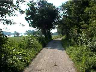
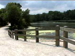 The I&M Canal bike trail starting from Channahon |
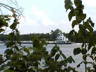 A barge on the Illinois River along the trial |
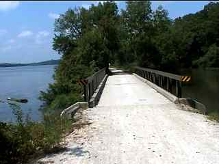 The Illinois River on the left and the canal on the right |
The I&M Canal Bike Trail (Illinois - 58m) is about 58 miles one way from Channahon to LaSalle/Peru Illinois is crushed stone, is very flat and is built from the original canal tow path. The path is not crowed and passes through a number of small towns along the way.
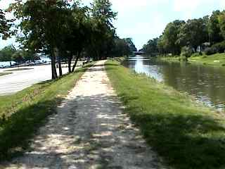 W.G. Stratton State Park near Morris |
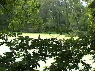 Some bright green still water |
 A scenic opening |
This article includes first hand descriptions and plenty of photos of the Illinois and Michigan Canal bike trail from Channahon (going west) to Marseilles (August 2003). I am including some of the standard bike trail information, and stats, as well as some background on the historical significance of the canal, but my intent is to capture the look and feel of the trail primarily from first hand descriptions and photos.
Bike Trail Information
Distance: 58 miles one way from Channahon to LaSalle/Peru
Illinois
Surface: Crushed limestone, flat
The I&M (Illinois and Michigan) Canal History:
Although this article (and photo pages) are primarily about what is now the I&M "Bike Path" (for many of us), don't underestimate the significance of of the I&M canal relative U.S. and Chicago history and the development of Chicago and the entire United States!
The Illinois & Michigan Canal was completed in 1848 and connected the Great Lakes to the Mississippi River along an Indian portage route. The canal extended from the Chicago River to the Illinois River (97-miles) at Peru, Illinois.The canal transformed Chicago from a small settlement to a critical transportation hub between the East and the developing Midwest. The canal was really a key element in making Chicago into the city that it is today. The towpath, and bike trail along the canal, runs through a rural and wooded landscape linking a number of towns laid out by the original canal commission.
I didn't realize the historical importance of the canal until recently, when I read a book on the subject and saw a PBS special on the I&M canal. Being a native of the Chicago area, I found this to be very interesting and would recommend that you check out the history behind this "bike trail" as well as checking out the trail itself... I think the next time I do this ride, I will have a much deeper appreciation of the canal and trail... (and now back to the bike path info...)
This is a great trail for distance riding and is flat and very scenic. You can take breaks (get food and/or ice cream, etc.) at some of the towns along the trail. We had a fantastic ice cream break at a place called Tolis Calfe (that's not a typo) in Morris (ice cream cones can be like nirvana after about 50 miles and little else to eat!)
A couple of practical things to keep in mind for this trail are:
Much of this trail has the river on one side and/or the canal on the other and goes through some wet (swampy) areas. If you stop for a break, on the trail itself, you can get eaten alive by mosquitoes. There can also be swarms of nats around sunset.
If it is still mosquito season (summer), plan your breaks in open breezy areas or in one of the towns along the path, wear white clothing and/or bring mosquito repellent...
There are some pretty long and deserted stretches of bike path between one town and the next. Be sure that your bike is in good working condition and bring whatever you need for any potential repairs along the way...
I don't want to scare you off, because this really is a very nice trail, but I have not seen these things mentioned in other articles on the trail and I think that you should at least be aware of them (especially for a long ride on this trail).
| . |
I&M Canal Bike Trail Photos
Here's the photo tour of the I&M Canal Trail, from Channahon (going west) to Marseilles (August 2003).
I&M Canal Trail Photos 1 - Starting in Channahon
I&M Canal Trail Photos 2 - Passing McKinley Woods
I&M Canal Trail Photos 3 - Stratton State Park near Morris
I&M Canal Trail Photos 4 - West of Stratton State Park
I&M Canal Trail Photos 5 - Wetlands and Seneca
I&M Canal Trail Photos 6 - Near Marseilles
I&M Canal Trail Photos 7 - Back to Morris
Here are the fall photos of our trip from Marseilles to Split Rock ~ Just before La Salle, Illinois on 10/15/2012.
I&M Canal Trail Fall Photos 8 ~ Marseilles and Ottawa
I&M Canal Trail Fall Photos 9 ~ Locks 11 and 12
I&M Canal Trail Fall Photos 10 ~ East of Utica
I&M Canal Trail Fall Photos 11 ~ Into Utica
I&M Canal Trail Fall Photos 12 ~ Utica to Split Rock
I&M Canal Trail Fall Photos 13 ~ Ghost Bridge
I&M Canal Trail Fall Photos 14 ~ Back to MarsiellesHere's the GPS Map of the ride above.
I hope you enjoy this tour and hope it inspires you to take the trail(s) in the spring, summer or fall (when it is cool and dry preferably) and/or provides a nice memory of your trips in the winter when you may not be able to get out there and enjoy it (as much anyway).
I've kept the format to medium sized and medium quality photos split into multiple pages to keep the download times reasonable for all connetions, including dial ups. Most of the photos (with a few exceptions) are sequential going from Channahon to Marseilles...
- Bike Computers
- Bicycle GPS
- Bicycle Bags
- Bicycle Clothing
- Bicycle Lights
- Bicycle Locks
- Bike Parts
- Bikes
- Kids Bikes
- Exercise Bikes
- Bike Trainers
- Bicycle Car Racks
- Bicycle Hydration
- Bicycle Accessories
- Bike Blog
- Algonquin Road Trail
- Busse Woods Trail
- Chain O'Lakes Trail
- Chicago Lakefront Trail
- Deer Grove Bike Path
- Des Plaines River Trail
- Evanston Lakefront
- Fox River Trail
- Great River Trail, Illinois
- Great Western Trail
- Green Bay Bike Trail
- Hennepin Canal Trail
- I&M Canal Bike Trail
- Illinois Prairie Path
- Illinois State Beach Bike Path
- Inverness Trail
- Jane Addams Trail
- Kankakee River Trail
- Long Prairie Trail
- Millennium Trail
- Moraine Hills Trails
- North Branch Trail
- North Shore Bike Path
- Old Plank Road Trail
- Palatine Trail
- Paul Douglas Trail
- Poplar Creek Trail
- Prairie Trail
- Prospect Heights Trail
- Randall Road Trail
- River Bend Trail
- Robert McClory Bike Path
- Silver Glen Trail
- Skokie Valley Trail
- Thorn Creek Trail
- Virgil Gilman Trail
- Wauponsee Glacial Trail
- 400 State Trail
- Ahnapee Bike Trail
- Badger State Trail
- BATS Crystal Lake Trail
- Cannonball Path
- Elroy Sparta Trail
- Great-River-Trail
- Kenosha Trail
- LaCrosse-River-Trail
- Military Ridge Trail
- Oak Leaf Trail
- Peninsula State Park Trail
- Red Cedar Trail
- Root River and Racine Trails
- Seven Waters Trail
- White River Trail